1. Phoenix and Scottsdale
Discover why Frank Lloyd Wright found inspiration in these twin cities – and see the architect’s influence writ large
At dusk, downtown Scottsdale’s Valley Ho Hotel looks like the sort of place Don Draper would come to get away from it all. As the sun sets, guests sip cocktails by the patio fire pit, reclining on loungers that mix retro and modern design as if they were drawn for The Jetsons, then magicked into reality.
Yet this is no ersatz recreation of ’50s cool – it’s the real thing. Opened in 1956, the Valley Ho was a magnet for the likes of Bing Crosby, Tony Curtis and Janet Leigh. In 1957 it hosted the wedding reception of Robert Wagner and Natalie Wood, and it’s said that Zsa Zsa Gabor and her daughter Francesca rode horses around the hotel. Presumably not while the wedding was still going on.
‘We were a resort community back then, so Hollywood stars came here, because the paparazzi wouldn’t follow them,’ explains Ace Bailey, who runs an art and architecture tour in Scottsdale. ‘They could come here for “recreation” and maintain their anonymity.’
That much hasn’t changed. ‘To this day, the hotel will not release its current guest list to anybody except hotel staff, so it’s very discreet,’ adds Bailey, before reeling off a list of contemporary Hollywood stars she’s spotted hanging around the lobby recently.
The Valley Ho is not alone. Scottsdale and Phoenix are dotted with superb examples of mid-century architecture and design, much of which displays the fingerprints of the man generally regarded as America’s greatest architect, Frank Lloyd Wright.
Wright came to Phoenix in 1928 to work as a consultant on the Arizona Biltmore Hotel. A decade later, he returned to build Taliesin West, his winter home, school and studio 26 miles from Phoenix. The real genius of Wright’s design is his ability to ‘bring the outside in’. In the living room, the sunlight streaming through the glass walls and translucent roof makes the garden feel like just another part of one contiguous space.
In the drafting room where Wright created perhaps his best-known work, New York’s Guggenheim Museum, a group of young architects scratches away. They are students at the Frank Lloyd Wright School of Architecture and just as in Wright’s day, they are encouraged to get their hands dirty. They have to build their own rudimentary abode in the nearby desert to ensure they truly understand the basics of designing shelter.
And the students are spoilt for inspiration. Phoenix Art Museum sprawls over 26,500 square metres, housing work from the Renaissance to today. In one hallway, adults and children alike lose themselves in their distorted reflections in the polished surface of Anish Kapoor’s sculpture Upside Down, Inside Out. Further on, they wander through American art history from an iconic portrait of George Washington by Gilbert Stuart to modernist work by Georgia O’Keeffe.
Across town at the Scottsdale Museum of Contemporary Art, visitors gaze at Knight Rise, an installation by the Californian artist James Turrell that frames the sky in a disorientating fashion. Upon leaving, they’re hit by a riot of colour from graffiti artist James Marshall, also known as Dalek.
Even public buildings, like the Scottsdale City Hall and Library, are prime examples of Southwestern architecture, influenced by the clay adobe dwellings once built by the native Hopi people. ‘It’s minimalist, without any froufrou,’ says Bailey. ‘We’ve got great neighbourhoods full of mid-century architecture, as well as structures that are true adobe compounds. It’s quite a mix.’
The blurring of past and present is still going on back at the Valley Ho, where the drinkers are determinedly stretching the cocktail hour into the night. They’ve moved indoors to sit beneath concrete block walls that show Frank Lloyd Wright’s undying influence. While they toast to the future, the music in the air is pure Rat Pack.
From central Scottsdale, follow the Arizona 101 Loop north for 35 minutes to reach the edge of the McDowell Sonoran Preserve.
2. McDowell Sonoran Preserve
Hit the dusty trail between majestic saguaro cactuses as you explore the archetypal desert of the American West
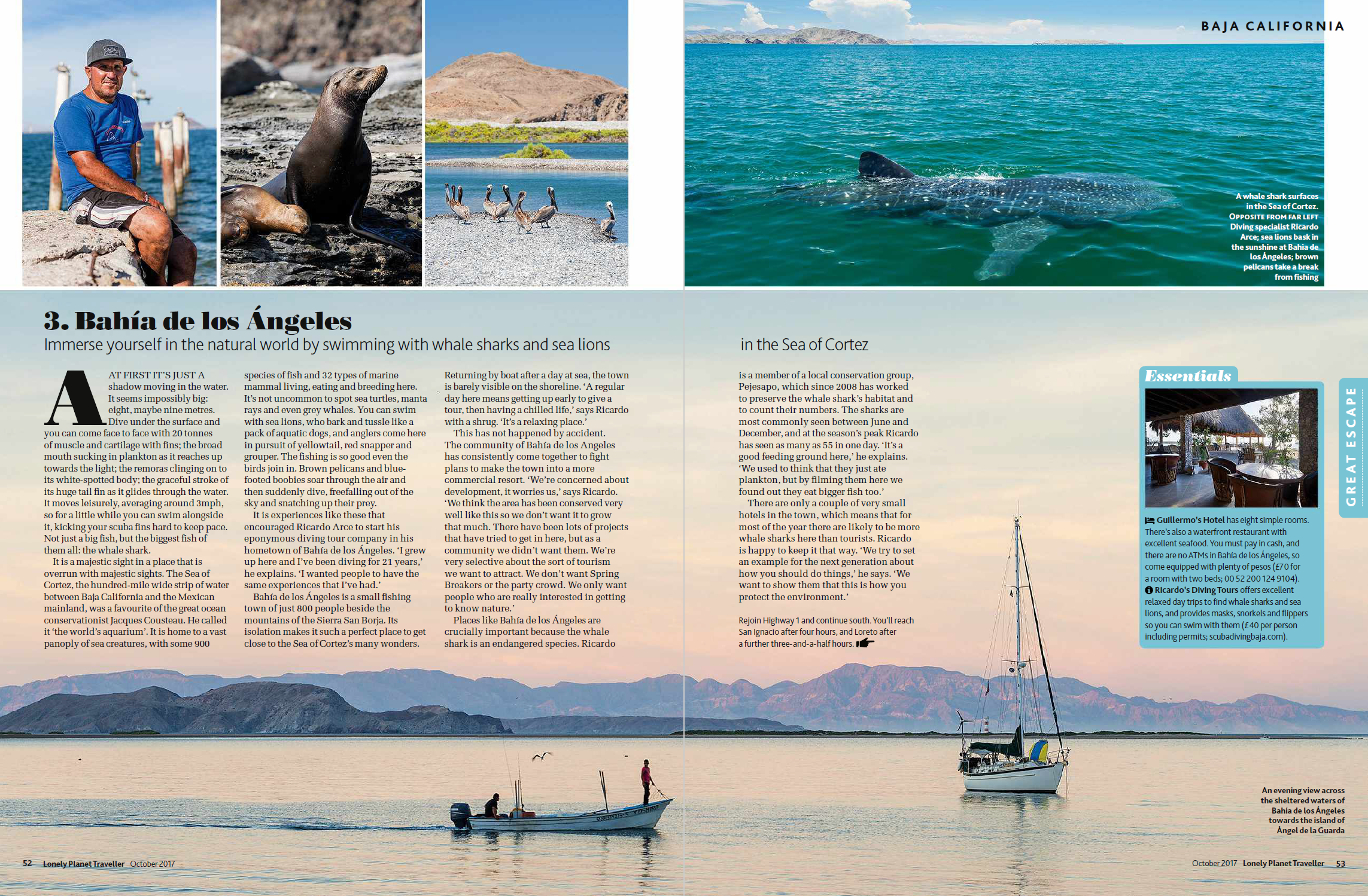
Like the wagon trains that once traversed this desert, the sun is heading west. As the light moves, the shape of the huge boulder known as Cathedral Rock seems also to warp and mutate as shadows pass across its face. In the foreground, giant saguaro cactuses stand proud and tall. Instantly familiar from their appearance in many hundreds of Westerns, they are also ancient markers. The saguaro grow an average of a foot per decade, so those towering 20 or 30 feet will have stood on that spot for around 250 years. They are the constant watchmen in the ever-changing landscape, yet adventure guide Phil Richards has a more immediate concern.
The ground is scattered with balls of jumping cholla, a cactus that looks so cuddly it has earned the nickname ‘teddy bear cactus’. Phil has just lightly placed one of these balls onto his arm to demonstrate their strength and he’s already struggling to prise it free from his flesh with a length of wood.
‘They may look soft, but if they get onto you they won’t let go,’ he explains, pointing out the strong barbs that cover the plants. They’re known as “jumping” because they latch on so hard even when brushed past that cyclists and hikers will swear they jumped out at them. Their real purpose is to hook themselves onto passing rodents and when the poor creatures try to burrow down, they’ll find themselves stuck to the cactus and inadvertently doing the job of planting it. Invariably, the animal is killed in the process. ‘This gives rise to their other name,’ says Phil darkly. ‘The “skeleton cactus”.’
For a desert, the Sonoran has a relatively lush terrain and is covered in plant life that blooms in spring. However, that doesn’t make it an easy place to survive. Phil takes issue with John Ford’s 1948 western 3 Godfathers, in which John Wayne finds himself stranded in this very desert. In need of water, he hacks the top off a barrelhead cactus and squeezes the pulp into his flask.
Sadly, this sort of thing only works in the movies. In truth, the moisture in a barrelhead is so filled with acids that it will most likely give you diarrhoea – not useful if you’re already dehydrated and stranded in a desert.
‘This is a unique desert,’ says Phil. ‘We’ve got about 3,500 varieties of plant out here, including a number of cactuses found nowhere else, and that’s because of the climate. We don’t get a hard freeze.’
The desert, ranging from Sonora in Mexico to the south of California, covers a swathe of Arizona. Here in the McDowell Sonoran Preserve, there are 30,200 acres of protected land: nothing can be built and no motorised vehicles may travel its 146 miles of trails.
‘It’s very peaceful here,’ says Phil, whose transport of choice is the mountain bike. ‘The only things you hear are your gears shifting and your wheels on the gravel.’ His quiet progress provides many opportunities to spot desert wildlife – he points out Gila monsters (venomous lizards), tusked, pig-like javelinas and grazing mule deer.
He says that it’s the beauty of the land itself, though, that keeps him coming back day after day, whether he’s guiding a group or not. ‘You can never get enough of the desert,’ he says, ‘so the best way to get more is just to ride out to a different spot.’
With that, he’s off again, dashing along a sandy trail, but still mindful enough to keep clear of the jumping cholla.
Take Interstate 17 north until you reach Flagstaff, then US-180 onwards to Grand Canyon National Park. It’s about a four-hour drive.
3. The Grand Canyon
Bear witness to the USA’s greatest landscape of all, then clamber down into it
The Grand Canyon gives no warning. Approaching from the south through the great thickets of ponderosa pine that make up the Kaibab National Forest, there is no indication of the spectacle to come. Deer dance between the trees, seemingly oblivious to their proximity to the void. Only at the precipice does the canyon reveal itself, the earth simply dropping away to reveal one of nature’s most audacious wonders. It is a mile deep and 18 miles across at its widest point. Gazing out at this great chasm of red rock shifts your perspective in a skipped heartbeat. The scale of it humbles man’s greatest constructions: stack three Empire State Buildings on top of one another and you still wouldn’t reach the rim. One lookout stop says it all: The Abyss.
It is not just the size of the canyon that startles but the sweep of history it illustrates. It is six million years since the Colorado River first found this route to the Gulf of California, and began slicing down through the soft top layers of dirt and rock. On it went, patiently cutting through sandstone and limestone before it reached its current level more than 1,500 metres below the rim. It is still getting deeper, although at a slower rate now that it has reached the hard basement rock. The river is now 730 metres above sea level and scientists believe it will keep going down, millimetre by millimetre, year after year, until it reaches the level of the sea, where all rivers stop.
To better understand the canyon, it’s necessary to leave your perch on the brink and descend into it. Hikers Katie and Nic Hawbaker, from nearby Flagstaff, have done so several times. Today, they’re climbing the Bright Angel Trail, the Grand Canyon’s most popular, which descends 1,370 metres to the Colorado River. From there, it joins the River Trail leading to Phantom Ranch in the canyon base, where they camped last night.
‘It’s totally different at the bottom,’ says Katie. ‘It’s magical. We can’t imagine how long it took to carve out the canyon or where the river was initially. It’s just so deep.’
Another way to attempt to get to grips with the sheer scale of the place is to get over it. From a Maverick Helicopters’ chopper, it’s possible to see the Painted Desert and follow the Colorado River before diving through the Dragon Corridor, the widest and deepest part of the canyon. For peak impact, though, it’s hard to beat the early moment when you’re ambling along 15 metres above the treeline of the ponderosas, then suddenly you’re 1,500 metres over the rushing waters.
It’s all a far cry from 1893, when hotelier Pete Berry first opened a crude cabin at Grandview. Berry had come to the canyon in 1890 as a prospector and staked the Last Chance copper claim 915 metres below. The ore was rich, but the vast cost of transporting it to the rim doomed the whole operation.
Before long, President Theodore Roosevelt realised the canyon needed to be protected. He made it a national monument in 1908, having declared: ‘Let this great wonder of nature remain as it now is. Do nothing to mar its grandeur, sublimity and loveliness. You cannot improve on it. But what you can do is to keep it for your children, your children’s children, and all who come after you, as the one great sight which every American should see.’
Leave Grand Canyon National Park by the East Gate and continue along Arizona 64 until you reach Cameron. Then take US-89 north towards Page. Allow two hours in total.
4. Antelope Canyon & the Navajo Nation
Watch the sunlight paint pictures in Antelope Canyon, teeter on the edge of Horseshoe
Bend and get close to the land in a traditional Navajo hogan
It is a cool, still morning and Baya Diné is awake early to tend to her flock. As the curly horned Navajo-Churro sheep graze across the wide-open plains, her big white Maremma sheepdog Elvis keeps the stragglers in check. Baya knows every inch of this land as if it were a part of her, from the spectacular curve of Horseshoe Bend a few miles north to Antelope Canyon in the east.
Baya’s family has farmed here for 15 generations. Her ancestors lived in hogans, homes built with cedar and juniper logs, and packed with earth, which could be taken down and moved seasonally. Baya herself grew up in her grandmother’s hogan, a permanent wooden structure which still stands and was, improbably, built with pieces of the set left over from the making of the 1965 epic The Greatest Story Ever Told, after her grandfather appeared in the film as an extra. Baya’s grandmother, who had always lived in buildings made of earth, considered it a palace.
‘My grandmother lived here the way the Navajo had lived for many generations,’ Baya explains. ‘She herded her sheep through this land and then down the ridge all along to where the town of Page is now. This is a harsh environment and they were just trying to survive, foraging and living off the land. They were one with it, really. This was part of them and their way of life.’
Baya’s land is in the west of the Navajo Nation, which at 16 million acres is the largest Native American reservation in the US. Although her ancestors moved their homes to different spots regularly, they have left no trace beyond a few petroglyphs, arrowheads and shards of broken pottery.
‘You’d never know now where their homes were,’ says Baya. ‘These days there are buzzwords, like “sustainable” and “green-built”, but that was just a way of life for Native Americans. They reused and recycled way before it was the thing to do.’
On the land where Baya now stands, the ancient Navajo stories say there was an antelope birthing area. The animals also gave their name to the nearby Antelope Canyon, although the Navajo refer to the area as ‘Tsé Bighánílíní’, which translates as ‘the place where water runs through rocks’.
Entering the now-dry canyon on a Navajo-run tour, visitors are awed into hushed tones when they see how water has sliced a narrow crevasse through the sandstone. Inside the slot canyon there’s an otherworldly atmosphere, as the only light comes from sunbeams playing tricks upon the canyon walls as they fall 40 metres. Flash flooding is still a danger and tour guides with torches pause to point out where previous floods have lodged trees high between the canyon walls.
Photographers jostle each other for the best spots and angles – no surprise considering the world’s most expensive photograph was taken here. Landscape photographer Peter Lik sold Phantom, an image of dust in the canyon appearing to take the form of a ghost, for $6.5m in November 2014.
West of Antelope Canyon, on the other side of the small town of Page, sits Horseshoe Bend, where photographers have no such problem competing for a spot. The only danger here is getting too close to the 300-metre drop that overlooks the meandering path of the Colorado River as it travels west from Lake Powell to the start of the Grand Canyon itself. This is that same canyon on a more intimate scale and among the tourists taking selfies there are also joggers from Page who come simply to marvel at nature’s signature, carved deep into the earth. Standing on the precipice, it’s easy to understand what Baya means when she explains why the Navajo have stayed in this place for so long. ‘This land,’ she says, ‘has its own special power.’
Take US-89 south to Flagstaff and then switch to US-89A for the scenic drive through the valley to Sedona. The trip will take around three hours.
5. Sedona & the Verde Valley
Reap the harvest of Arizona’s growing wine scene and dine beneath majestic red rocks
It’s early on Sunday afternoon and winemaker Eric Glomski is welcoming guests to Page Springs Cellars. Some have come to enjoy the sunshine on a stroll through the vineyards, but most are here to while away the hours on the top deck of the cellar, uncorking bottles to taste the fruits of the fields that stretch out below.
Eric is something of a viticultural celebrity in these parts. He used to run the Arizona Stronghold winery with an actual rock star, Tool frontman Maynard James Keenan, and he bought the Page Springs Cellars site in 2003. Wandering into the vineyards past the fast-flowing brook which gives the winery its name, you’d be forgiven for thinking you’re in Burgundy in France or Portugal’s Douro Valley.
‘Everyone asks, isn’t it too hot and dry in Arizona to grow grapes?’ says Eric. ‘I remind them that grapes originated in the Middle East, Lebanon and Syria, so they’re very adaptive. There are different microclimates throughout the state. If I were to liken us to anywhere, in terms of climate, we’re closest to parts of Spain, France and Italy – some of the homelands of grape growing.’
So, here in the Verde Valley, Eric finds terroir to suit the grapes. One side has limestone soil, just as at Châteauneuf-du- Pape in France, while the other side is volcanic, like on Sicily’s Mount Etna. ‘We’re also trying new things,’ he says. ‘Just because it works somewhere else doesn’t mean it will work here.’
So far, something is working. This is just one of 22 vineyards that have sprung up in the valley to feed Arizona’s burgeoning wine scene. Perhaps the most scenic is Barbara Predmore’s Alcantara vineyard at the confluence of the Verde River and Oak Creek, where she also hosts weddings at a palatial villa that looks like it’s been transported wholesale from Ancient Rome.
While the grapes may be grown down here, most of it seems to get drunk up the valley in Sedona. Here the landscape changes again, adding imposing red rock formations that rise from the earth like Martian mountains and have attracted ambitious climbers for decades.
It’s not just the scenery that brings people to this laid-back town. New Age types have also long been attracted by the belief that benevolent swirling vortexes of ‘subtle energy’ emanate from the land. The result is a town with a thriving arts scene and plenty of vegetarian cafés, including Chocola Tree, where you can pick up a kale smoothie while recharging your crystals. The emphasis on organic, locally grown food extends to high-end restaurants, the star of the scene being Mariposa, a Latininspired grill. Chef Lisa Dahl has grown used to hearing about the impact Sedona’s panoramic views have on her customers. ‘I’ll never forget one guy telling me that sitting on the patio is like being on the ocean,’ she says. ‘There’s a level of serenity you feel here that’s overwhelming.’ As Lisa heads back to the kitchen, burgers, tostadas, cocktails and local wine appear. Maybe there’s something to these swirling energy vortexes after all.
Published in Lonely Planet Traveller, March 2017.


 Published in Lonely Planet Traveller, June 2020.
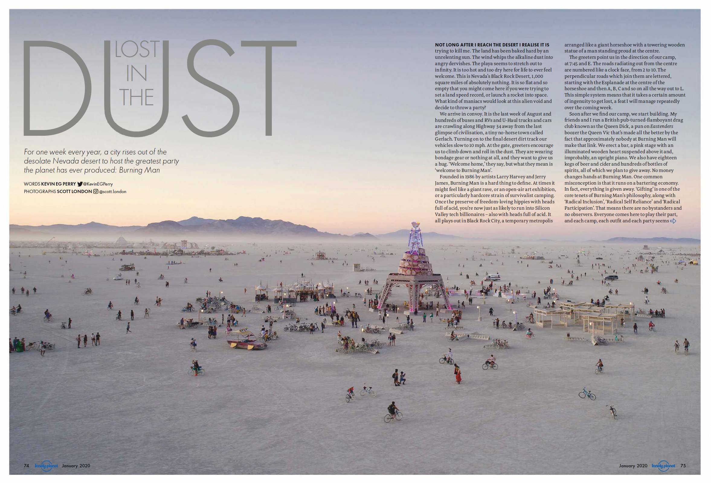 Not long after I reach the desert I realise it is trying to kill me. The land has been baked hard by an unrelenting sun. The wind whips the alkaline dust into angry dervishes. The playa seems to stretch out to infinity. It is too hot and too dry here for life to ever feel welcome. This is Nevada’s Black Rock Desert, 1,000 square miles of absolute


 When the sun is shining in Vienna, there are few better places to be than the gardens of the Prater. Home to a sprawling amusement park – notable for the Ferris wheel where Orson Welles delivered his nihilistic monologue in The Third Man – it also contains one of the city’s most famous beer gardens. The Schweizerhaus has existed in this location in one form or another since 1766, and its reputation rests on doing two simple things very well: perfectly-soft, meaty pork knuckles the size of rugby balls, and glass tankards filled with beer so frothy that it’s impossible to drink them without getting bubbles on your nose.


 Whether or not you’ve sat through an episode of I’m a Celebrity… Get Me Out Of Here!, you’re probably familiar with the concept of a ‘bush tucker trial’. Since the TV reality show set in the Australian jungle first appeared on screens, the phrase has become synonymous with celebrities being challenged to eat a variety of unsavoury-looking insects and animal parts.
 Published in Lonely Planet Traveller, May 2019.
 Published in Lonely Planet Traveller, April 2019.


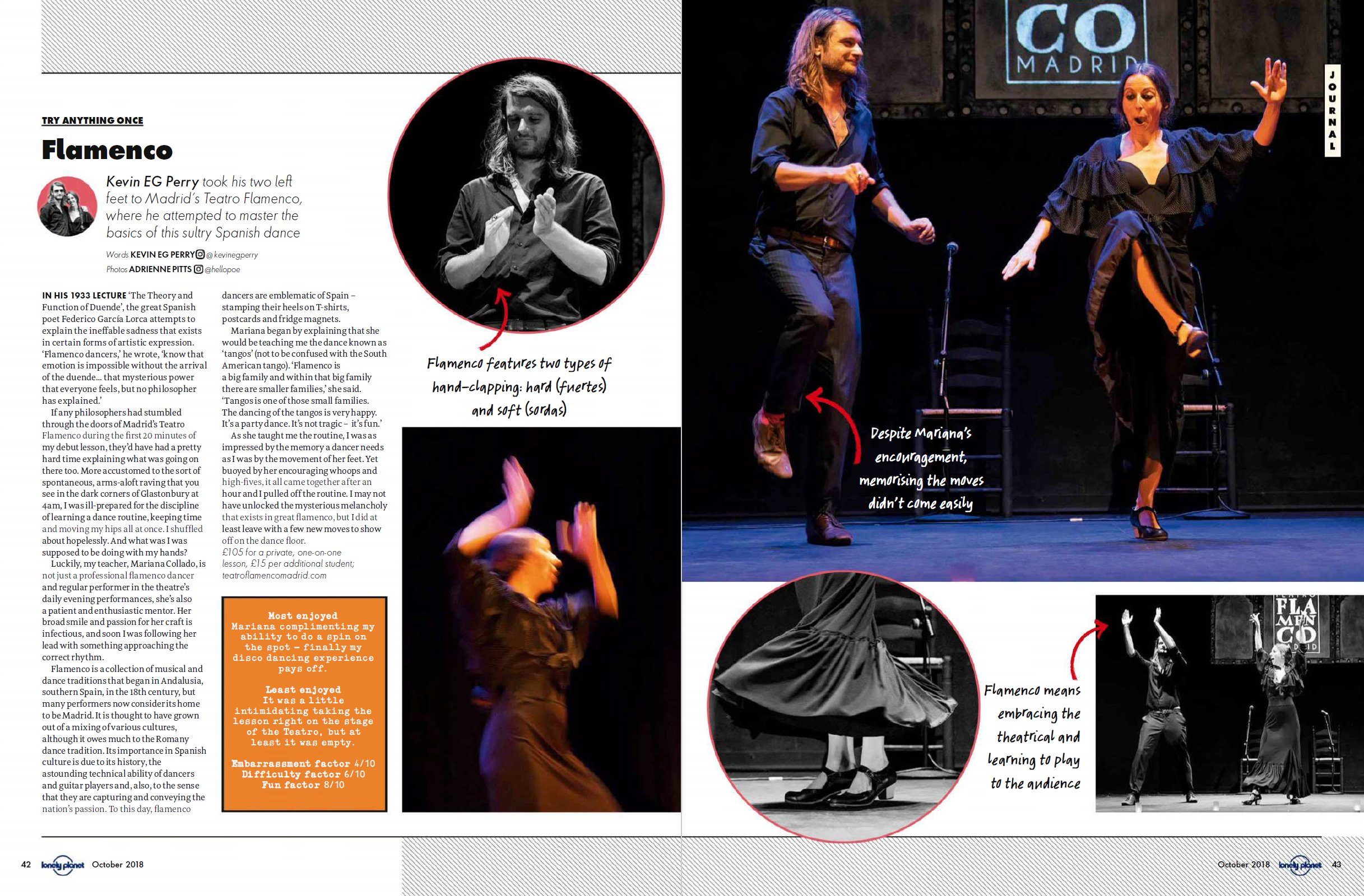 Originally published in Lonely Planet Traveller, October 2018.